
http://www.bertinettobartolomeodavide.it/hardwaresoftware/Joy/Joy2.html
http://www.bertinettobartolomeodavide.it/hardwaresoftware/Joy/Joy2.html
Mi sono sempre chiesto se sia effettivamente possibile riprodurre in modo semplice dal Basic del C64 un file SID... Bene la risposta è arrivata:

SEGUONO TUTTI I DETTAGLI PRESSO IL MIO SITO WEB...

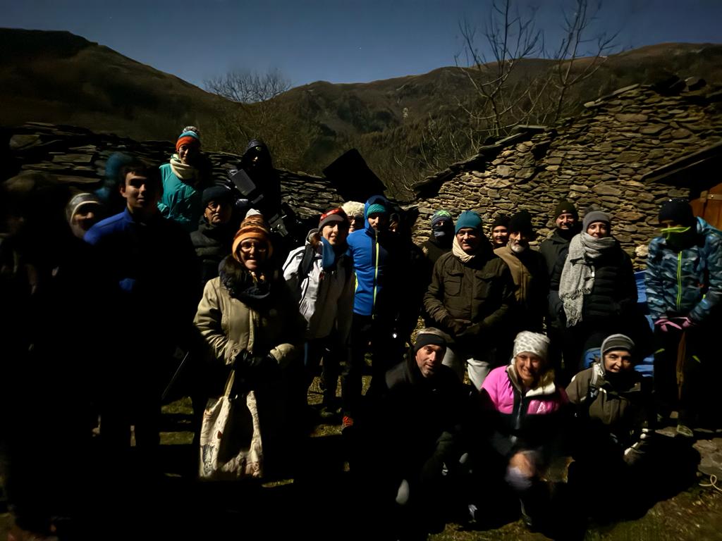
E' una bella soddisfazione per me scrivere che la serata di astronomia patrocinata dall'Università di Valle Po è stata un gran bel successo. Già al ritrovo fissato per le 20.30 presso il parcheggio di Prato Guglielmo si percepiva una certa allegria nel gruppo. Quindi lo spostamento con l'auto a curva Droe e da lì camminata di circa un 1,5km tra boschi e pascoli illuminati solamente dalla Luna Piena per raggiungere il sito di osservazione presso Borgata Borsetti. In baita un piccolo ristoro e un po' di calore tra una stella e l'altra. Due erano i telescopi allestiti ieri sera 28-11-2023, un rifrattore apocromatico e uno Smith Cassegrain, così da far percepire al meglio le differenze visuali tra strumenti differenti. Il tour astronomico è partito dall'immancabile 'Stella Polare', per spostarsi su costellazioni, altre stelle tra cui Deneb, poi le Pleiadi, La grande Nebulosa di Orione, i pianeti Giove e Saturno. Oltre a tanti altri oggetti... Moltissime le domande da parte dei partecipanti, molto attenti alla tematiche esplorate dalla spiegazione degli astrofili Sergio Franco e Bertinetto Bartolomeo Davide.
La Luna Piena di certo ha aggiunto qualche livello di difficoltà alla serata ma comunque la scelta di oggetti ugualmente visibili nonostante l'alta luminosità del fondo cielo non è mancata.
Tutti gli 'aspiranti astrofili' si sono dimostrati tenaci nei confronti del freddo che dopo le ore 22.00 ha iniziato ad essere battente! Quindi la serata si è conclusa poco dopo le ore 23.00.
Si ringraziano tutti i partecipanti.
Pagina Facebook Gruppo Amici Astrofili Valle PO:
https://www.facebook.com/groups/192804784476834
La mia pagina web dedicata all'astronomia amatoriale:
http://www.bertinettobartolomeodavide.it/archimedespace/index.html


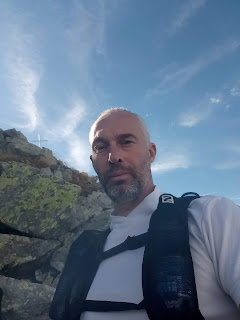
 |
| Pilone Cima Costa Rossa |
Avevo veramente bisogno di uscire per restare per qualche ora libero in mezzo alla tranquillità delle montagne. In questi due mesi sono rimasto fermo per via di un infortunio alla caviglia avvenuto durante l'avventura di Casteldelfino... Si qualche piccolo giretto l'ho fatto, soprattutto per la mia piccola uscita delle balle(quella a San Bernardo da Envie), che è un bel giro che adoro ma che ho soprannominato così visti i 'miseri' 7 chilometri di estensione. Meglio di niente!
Ero già andato a fare un sopralluogo il giorno prima di 3 chilometri sopra Boves, perché è una zona che conosco veramente poco, anche se qualche anno prima comunque avevo tentato con qualche sporadica perlustrazione...
 |
| Bisalta dall'auto |
Le punte della Bisalta mi hanno sempre incuriosito, dato che dalla macchina quando vado verso Cuneo le osservo sempre dal parabrezza. Mi ricorda un po' il Monte Bracco ma più mastodontico dato che la sua punta più alta arriva fino a 2400m(Costa Rossa) e di cime qui ce ne sono diverse(ben 4).
Orario di partenza 9.30 dallo stretto vallone all'ombra sopra Boves(frazione Castellar), a quota 880m dove ho lasciato l'automobile. Ho aspettato un po' a partire perché è una vallata molto fredda ed il sole non compare fino a dopo le 10.30 in questa stagione.
Una risalita di qualche chilometro ed incontro il primo bel rifugio Ceresole, molto carino(totalmente i legno) e lì mi siedo un paio di minuti per uno spuntino, oltre a riempire le borracce di acqua 'di fonte'. Incrocio in questo punto alcuni ragazzi che già stavano scendendo.
 |
| Rifugio Ceresole |

Proseguo sempre in salita, dato che su questo tragitto non ci sono punti dove spiana, quindi si procede col dislivello positivo. Gli alberi ad un certo punti finiscono quasi improvvisamente per lasciare spazio ai pascoli. Inizia a vedersi un panorama stupendo fatto di montagne alpine sparse in ogni direzione verso i punti cardinali Nord, Sud ed Ovest. Mentre verso Est si fa spazio una poderosa pianura padana! Una giornata dal cielo terso con estesissima visuale.

 |
| Il Monviso dalla Bisalta |

Raggiungo la prima punta(Costa Rossa al Km 5,7 all'ora circa delle 12.30 per un nuovo spuntino(mi decentro leggermente per starmene tranquillo dato che lì c'era molta gente). Dopo aver fatto le foto di rito accanto al pilone inizio nuovamente a sgambettare osservando le altre punte più basse a ridosso della pietrosissima cresta. Andando verso lo 'Sperone Cenrale'(seconda punta di 2270m iniziano ad esserci svariati massi da attraversare che attraversano il sentiero e che rallentano moltissimo il passo. I bastoncini lunghi qui mi hanno aiutato ma le mani in alcuni punti si sono dimostrate indispensabili per fare da punto di appoggio! Giusto una foto e poi ancora avanti presso il sentiero che diventa una vera propria pietraia verso la terza cima al chilometro 8,3(Bisamauda, vera cima della Bisalta) a quota 2250m. Avanzo ancora un pezzo verso una la quarta cima e anche se quella è più bassa, faccio fatica dato la pietraia si inasprisce ulteriormente a fronte di un sentiero per nulla segnato salvo che con qualche montagnola di pietre poco visibile(Anticima Bisalta 2190m). Qui le persone sono poche e decido di rientrare al chilometro 8,5 perché l'anello che avevo preventivato di chiudere dopo aver raggiunto tutte le punte della Bisalta, a quel punto mi rendo conto che non è fattibile a causa della pericolosità del tratto prima della lunga discesa finale. Tra l'altro fa effetto il grande numero di foto cimentificate alle pietre di vittime di questo punto di montagna(attenzione la montagna è pericolosa!) e vedendo il difficile sentiero la cosa non mi stupisce affatto.
 |
| Pilone Costa Rossa dalla punta a fianco |


Allungando il tragitto di 3 km buoni faccio 'dietro front' e ripercorro tutte le cime con annessa pietraia. Il passo qui è nuovamente lentissimo ma poco male perché rivedere tutto quel panorama non ha prezzo. Inoltre sulla via del ritorno non incontro quasi più nessuno anche perché sono già nell'orario oltre le 15.00. La brezza dello spartiacque comincia a farsi sentire, così valuto se rimettere il pile ma rinuncio dato che per tornare a Costa Rossa avrò altro dislivello positivo e per evitare di sudare troppo, resto in maniche corte.

 |
| La cresta |

Quando abbandono le cime verso il rientro, ritrovo nel percorso al contrario nuovamente i primi pascoli e qui il sentiero diventa finalmente agevole e corribile. Faccio un nuovo piccolo spuntino(fichi secchi che adoro e quadratini di Grana, che consumo per tutto il tempo) e poi riparto per la discesa finale tra i boschi. Gli ultimi chilometri verso la macchina sono a ridosso del fiume che ha un basso livello d'acqua(come ormai tutti i fiumi alpini) ma che comunque fa il tipico rumore(decisamente calmante). Sgambetto lungo la stretta strada sterrata che dopo un po' diviene asfaltata. Al parcheggio incrocio un ragazzo che avevo visto in cima e faccio due chiacchere, quindi ritiro tutto in auto. L'arrivo conclusivo è avvenuto alle ore 17.05(stimo) per una percorrenza secondo il GPS di 20,66km e un tempo complessivo di 7 ore 36 minuti.
Considerando che dalla Bisalta ho capito che si può raggiungere Limone Piemonte, nelle prossime uscite non esiterò ad esplorare ancora questo angolo di provincia Cuneese!
A quest'ora praticamente tutti gli escursionisti erano spariti, ma si sa che in Italia la cultura della montagna è debole. Ci sono sempre molte persone che 'a parole' vorrebbero 'fare' ma poi nei fatti si perdono quasi tutti, purtroppo!
 |
| Uno scorcio della poderosa pietraia |
 |
| Vista a valle dalla pietraia |

Considerando l'infortunio menzionato al principio posso scrivere che il recupero è stato ottimo dato che non ho avuto male per nulla alla caviglia, cosa che apre le porte a nuove avventure a piedi grazie alla tecnica del Monoallenamento settimanale, che anche in questo frangente di pausa forzata si è comportato benissimo dato che non ho percepito l'interruzione. Due storte le ho prese sullo stesso arto nella discesa finale ma sono state 'metabolizzate' senza conseguenze.
PS: voglio puntualizzare che in questa avventura non sono più stato molto diligente a menzionare tempi cronometrati e chilometraggi dato che ormai sono molti anni che avanzo senza badare troppo ai 'numeri' ma comunque nelle avventure precedenti mi impegnavo a menzionarle nei video per far contenti di utenti a cui interessavano. Tutti i dati qui riportati sono stai quindi ricavati dalla traccia GPS esaminata dopo, durante la stesura di queste righe. Credo che per conformità ai pensieri che nutro da molto tempo sulle lunghe percorrenze a piedi procederò sempre in questo modo. Mi scuso con coloro che desiderano visionare i numeri ma comunque potranno farlo leggendo il testo che fa sempre seguito alle mie avventure a piedi. Orologio GPS e cellulare per me hanno sono la funzione di indicatori di direzione da seguire!
.png) |
| Mappa |
Aggiungo qui la traccia WikiLoc, anche se ho noato che presenta differenze dalla Traccia del GPS Garmin:
https://it.wikiloc.com/percorsi-escursionismo/tutte-le-punte-della-bisalta-28-10-2023-151642008
Video Live:

Pillar Cima Costa Rossa
I really needed to get out to spend a few hours in the tranquility of the mountains. In these two months, I have been still due to an ankle injury that occurred during the adventure in Casteldelfino... Yes, I did a few small rides, especially for my little "balle" outing (the one to San Bernardo da Envie), which is a nice ride that I love but have nicknamed that way considering its 'miserable' 7 kilometers in length. Better than nothing!
I had already done a reconnaissance the day before 3 kilometers above Boves because it is an area I know very little about, although a few years earlier I had tried some sporadic exploration...

Bisalta from the car
The peaks of Bisalta have always intrigued me, as I observe them from the car when I go towards Cuneo. It reminds me a bit of Monte Bracco but more massive since its highest point reaches 2400m (Costa Rossa), and there are several peaks here (4 in total). Departure time was 9:30 from the narrow valley in the shade above Boves (fraction Castellar), at an altitude of 880m where I left the car. I waited a bit to start because it's a very cold valley, and the sun doesn't appear until after 10:30 at this time of year. A climb of a few kilometers, and I encounter the first beautiful Ceresole refuge, very nice (totally wooden), and there I sit for a couple of minutes for a snack, in addition to filling the water bottles from the 'spring'. At this point, I cross paths with some guys who were already coming down.

Ceresole Refuge
I continue uphill since there are no points on this route where it levels out, so we proceed with positive elevation. The trees at a certain point almost suddenly end to make way for meadows. A splendid panorama of Alpine mountains begins to be seen in every direction towards the North, South, and West. While towards the East, a powerful Po Valley opens up! A day with clear skies and an extensive view.

Monviso from Bisalta
I reach the first peak (Costa Rossa at Km 5.7 at around 12:30 for a new snack (I move slightly off-center to stay quiet since there were many people there). After taking the customary photos next to the pillar, I start trotting again, observing the other lower peaks along the rocky ridge. Going towards the 'Central Spur' (second peak at 2270m), there are several boulders to cross that slow down the pace a lot. The long poles helped me here, but my hands proved to be indispensable at some points to provide support! Just one photo, and then further ahead at the path that becomes a real stone field towards the third peak at kilometer 8.3 (Bisamauda, the true peak of Bisalta) at an altitude of 2250m. I advance a bit more towards the fourth peak, and even though it is lower, I struggle because the rocky terrain becomes even more rugged in the face of a path hardly marked except for a few small piles of stones not very visible (Anticima Bisalta 2190m). Here, there are few people, and I decide to return at kilometer 8.5 because the loop I had planned to close after reaching all the peaks of Bisalta, at that point, I realize it's not feasible due to the danger of the stretch before the long final descent. Moreover, the large number of photos of victims of this mountain point has an effect (attention, the mountain is dangerous!), and seeing the difficult path does not surprise me at all.


Pillar Costa Rossa from the adjacent peak

Extending the route by a good 3 km, I turn around and retrace all the peaks with the accompanying stone field. The pace here is again very slow, but no matter because seeing that panorama again is priceless. Also, on the way back, I almost don't meet anyone anymore because it's already past 3:00 PM. The breeze from the watershed begins to be felt, so I consider whether to put on the fleece, but I give up since to return to Costa Rossa, I'll have more positive elevation, and to avoid sweating too much, I stay in short sleeves.

The ridge


When I leave the peaks towards the return, I find again the first meadows in the opposite direction, and here the path finally becomes easy and runnable. I have a new small snack (dried figs that I love and squares of Grana cheese, which I consume all the time) and then set off for the final descent through the woods. The last kilometers to the car are along the river, which has a low water level (like all Alpine rivers by now) but still makes the typical sound (decidedly calming). A leisurely walk along the narrow dirt road, which after a while becomes asphalted. At the parking lot, I meet a guy I had seen at the top, and we chat for a bit, then I pack everything into the car. The final arrival took place at around 5:05 PM (estimated) for a distance according to the GPS of 20.66 km and a total time of 7 hours and 36 minutes.
Considering that from Bisalta, I understood that I can reach Limone Piemonte, in the next outings, I will not hesitate to explore this corner of the Cuneo province again! By this time, practically all the hikers had disappeared, but we know that in Italy, mountain culture is weak. There are always many people who 'in words' would like to 'do,' but then in reality, almost all of them get lost, unfortunately! A glimpse of the powerful stone field View downhill from the stone field


Considering the injury mentioned at the beginning, I can write that the recovery has been excellent since I felt no pain at all in the ankle, which opens the doors to new adventures on foot thanks to the Weekly Mono-Training technique, which even in this moment of forced pause has behaved very well as I did not perceive the interruption. I took two twists on the same limb in the final descent, but they were 'metabolized' without consequences. PS: I want to clarify that in this adventure, I have not been very diligent in mentioning timed times and distances since I have been advancing for many years without paying much attention to the 'numbers,' but in previous adventures, I made an effort to mention them in the videos to make users who were interested happy. All the data reported here was therefore obtained from the GPS track examined later, during the writing of these lines. I believe that for consistency with the thoughts I have nurtured for a long time on long walks, I will always proceed in this way. I apologize to those who want to view the numbers, but they can still do so by reading the text that always follows my walking adventures. GPS watch and phone for me are only directional indicators!


.png)
Map
I add the WikiLoc track here, even though I noticed that it differs from the Garmin GPS Track:
Link to WikiLoc Track: https://it.wikiloc.com/percorsi-escursionismo/tutte-le-punte-della-bisalta-28-10-2023-151642008
Live Video:
Below is the detail of the reference links related to my ultratrail and trail
articles:
Very long distances |
Routes |
Competitions |
Solo adventures |
Publications |
Training strategy |
UltraTrail eBook


